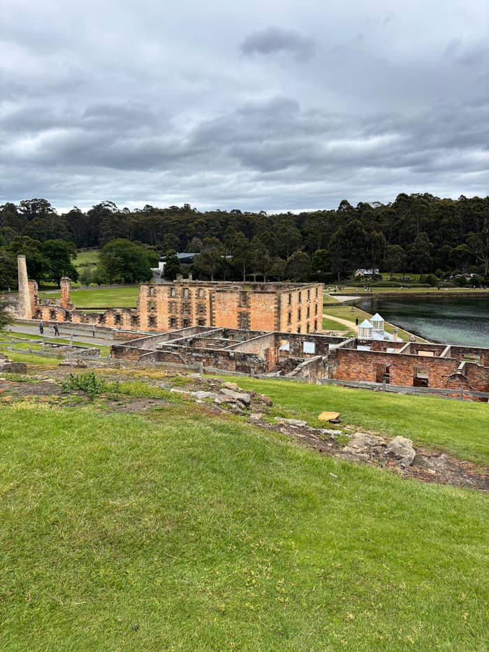
From Brooke St
Site tour
Guided full day
- Length8.5 hours
- At the site4 hours
- AlsoRemarkable Cave option
Choose your stop
Browse 23 stops
Start by picking a route; tap a pin or stop for its note and Google Maps.
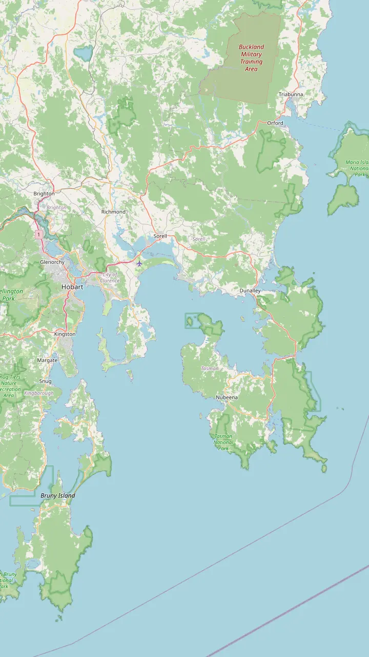
Leave Hobart on the Tasman Highway (A3) over the Tasman Bridge; Tassielink route 734 starts in Elizabeth Street.
Google MapsSorell lies 27 km from Hobart; here the signs send you onto the Arthur Highway (A9).
Google MapsDunalley is 30 km past Sorell; cross the canal bridge and the turn-off to the site comes 44 km later.
Google MapsEaglehawk Neck has the Dog Line sculpture and the Officers' Quarters of 1832.
Google MapsNubeena is where the Tassielink route to Hobart now begins, travelling via Port Arthur.
Google MapsThe historic site opens daily from 9:00am to 5:00pm and is closed on Christmas Day.
Google Maps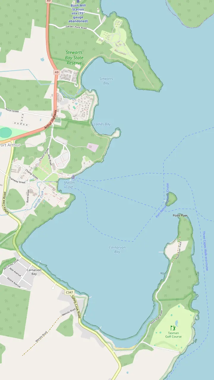
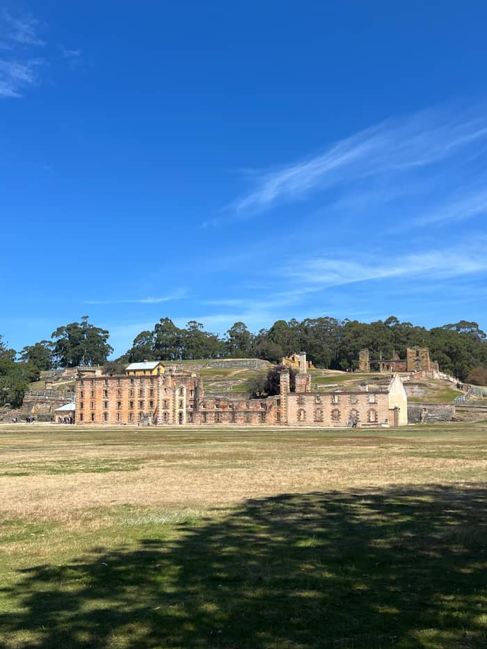
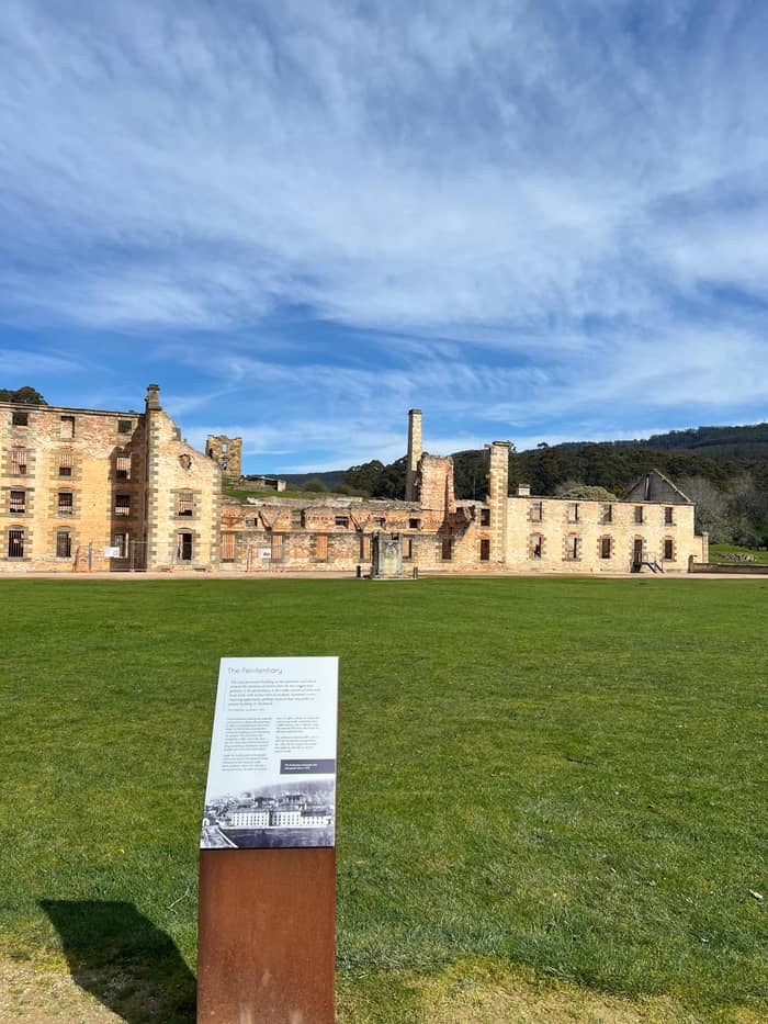
The Penitentiary began as a flour mill and granary and was turned into a prison between 1854 and 1857.
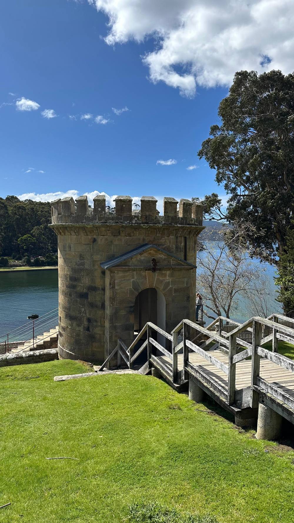
Google MapsThe Guard Tower is one of the convict-era ruins inside the historic site.
Google MapsThe Commandant's House is one of the site's furnished museum houses.
Google MapsThe Convict Church stands without a roof, and its bells ring every hour.
Google MapsThe Asylum, begun in 1864, now houses the quieter cafe.
Google MapsThe Memorial Garden is a quiet place of remembrance near the Visitor Centre.
Google MapsThe Isle of the Dead holds more than 1,000 burials from 1833 to 1877.
Google MapsPoint Puer was the British Empire's first institution built to reform convict boys.
Google Maps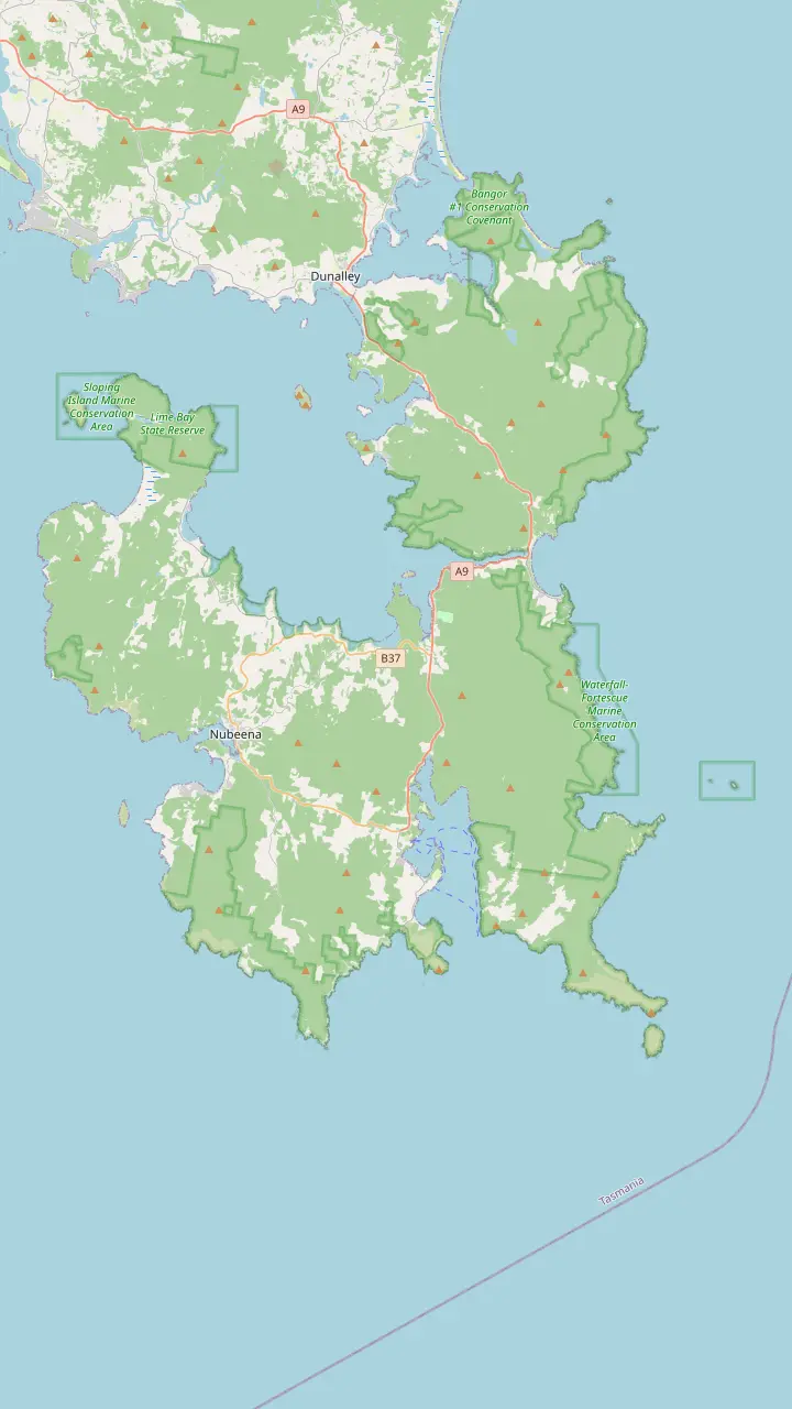
The Tessellated Pavement is best seen at low tide.
Google MapsThe Blowhole is reached by a wide loop track with a few stairs.
Google MapsDevils Kitchen and Tasmans Arch share a 600m sealed circuit of 20 minutes.
Google MapsDoo Town's shacks carry playful Doo names, a habit begun in 1935.
Google MapsThe Tasmanian Devil Unzoo opens every day at 9 am.
Google MapsPort Arthur Lavender sits at 6555 Arthur Highway, above Long Bay.
Google MapsRemarkable Cave is 115 steps down from its car park.
Google MapsThe Coal Mines Historic Site is free to enter.
Google MapsFortescue Bay is 12km of unsealed road off the highway and the start of the Cape Hauy walk.
Google MapsMap © OpenStreetMap contributors
Hobart to Port Arthur is a drive of about 90 minutes down the Arthur Highway. This guide covers the route town by town, the public bus, the day tours that drive for you and the stops worth making.
Editorial team, portarthurtour.quest · Updated November 8, 2026 · ~9 min read
Facts at a glance
Port Arthur Historic Site stands beside a harbour at the very bottom of the Tasman Peninsula, a little under 100 km from Hobart to the south-east.1 Discover Tasmania gives 95km and a 90min drive for the same trip.2 So if the question is how far is Port Arthur from Hobart, the honest answer is a little under a hundred kilometres of road.1 Both numbers describe the same road down the peninsula, and both end at the same visitor centre car park.
The site's own answer on time is that the drive from Hobart takes approximately 1.5 hours.3 The Tasmania Parks and Wildlife Service describes the same run to the national park next door as a 90-minute drive on sealed roads via Sorell.7 Read both figures as pure driving time with no stops, which is hard to keep to once the coast comes into view, so add a margin for the bends of the Arthur Highway south of Dunalley.
Build the stops into the plan from the start. The site itself suggests leaving time for the Tessellated Pavement at Eaglehawk Neck and for the Blowhole, Tasman Arch and Devil's Kitchen on the way.8 Eaglehawk Neck is a 1hr drive (76km) from Hobart by Discover Tasmania's figures, so it makes a natural first break, and Doo Town is a 70min drive (80km) out.9,10 Half an hour at each of these adds an hour to the day before you have even reached the convict ruins.
Options side by side
| Option | Time | Leaves from | Good for |
|---|---|---|---|
| Own car | About 1.5 hours | Anywhere | Freedom and stops |
| Tassielink 734 | Check timetable | Elizabeth Street | No car, low cost |
| Shuttle day | 9:30 AM-5:30 PM | Hobart pickup | Time on site |
| Site tour | 8.5 hours | Brooke Street Pier | A guided day |
| Active day | 10 hours | 20 Davey Street | Walks and devils |
Times as the site, the operator and the listings give them: the drive, route 734 from Elizabeth Street and the tour days.3,6,19
Leave Hobart on the Tasman Highway (A3), cross the Tasman Bridge, pass Hobart International Airport and carry on to Sorell, 27 km south-east of the city.4 In Sorell the signposts for the Tasman Peninsula put you on the Arthur Highway (A9), the road you stay on for the rest of the trip.5 That is the whole of how to get to Port Arthur from Hobart by car: the city, one bridge, one town and then a single highway south.
From Sorell it is 30 km to the township of Dunalley.11 Drive through the town to the bridge over the canal, cross it, and from there it is another 44 km until the turn-off to the historic site appears on your left.14 The Parks and Wildlife Service describes this crossing as a short bridge over a dredged canal, and it is the moment you leave the main island behind.15 Dunalley is also the last sizeable stop before the peninsula, so it is a good place for a coffee.
South of Dunalley the road runs down the Forestier Peninsula to Eaglehawk Neck, where a narrow isthmus joins it to the Tasman Peninsula.12 Discover Tasmania puts the isthmus at 100m wide, the only thing keeping the peninsula from being an island.16 The Neck is about 20km north of the historic site, so once you are across it the last stretch is short.17 Just past the Dog Line, turn onto Blowhole Road (C338), then follow Tasmans Arch Road to the arch and Devils Kitchen.18
Fill the tank in Hobart or Sorell. On the peninsula most fuel stops shut before 6:00pm, though the township has its own fuel station and store less than 1km from the gates.22,23 Discover Tasmania warns that some fuel stations close as early as 5pm in remote regions, which matters if you stay late for a night tour.24 Electric cars can charge at the Tesla destination chargers at the Lufra hotel at Eaglehawk Neck and at McHenry Distillery at Port Arthur, which are open to all EVs.25
The Arthur Highway is sealed, but many smaller roads on the peninsula are unsealed or rough, and some hire agreements limit where you may drive, so read yours before you leave the highway.20 Large wallabies and wombats are common, and they are most often met on the roadside at dawn and dusk.26 The Parks and Wildlife Service also asks visitors to avoid driving through its reserves at night where possible.27 Try to time the return so you are off the peninsula's back roads before nightfall.
Do not count on your phone. Mobile service at Port Arthur works only for Telstra and Optus customers and can be patchy in places, although the site offers free Wi-Fi called PAHSMA Public across the grounds.28,29 Download maps and the free audio guide before you go. Public toilets on the way are at Sorell, Dunalley and Murdunna.30 Parking at the site is free, but the car park fills quickly at peak periods, so arriving early gets you a bay near the entrance.31
Pick your way down
Begin with what counts most on your day out, and the right way down follows.
If I want to stop wherever I like
Drive yourself
The drive takes approximately 1.5 hours without stops on sealed highway.3,20
If I have no car and a small budget
Take the Tassielink bus
Route 734 runs via Port Arthur from Elizabeth Street in Hobart.6,19
If I want a guide and no driving
Book the site tour
It runs 8.5 hours from Brooke Street Pier with 4 hours at Port Arthur.
If I want the most hours at the site
Take the shuttle day
It reaches Port Arthur at 12:00 PM and leaves at 4:00 PM.
If I want walks and wildlife too
Choose the active day
It adds the Waterfall Bay walk and the Tasmanian Devil Unzoo.
Day tours from Hobart
From Brooke St
Guided full day
Pickup
Shuttle on a timetable
From Davey St
Walks and devils
Tasmania has no regular passenger train services, so buses carry the public transport load.57 Tassielink Transit runs the most extensive regional network, serving more than 50 regional and remote towns.58 Its Tasman Peninsula route is numbered 734, and it now starts at Nubeena and travels via Port Arthur on its way to and from Hobart.6,33 That is the answer to how to get to Port Arthur from Hobart by public transport.
On weekdays the operator runs one return trip a day, in school terms and school holidays alike.59 On weekends there is a daily return on Saturday and a daily return service on Sunday.60 All services start and finish at Elizabeth Street, by the town hall, in Hobart.19 The timetable itself is managed through Transport Tasmania, so look up the current times there before you build a day around them.61
A single return service gives you a fixed window at the site, so compare it with what you want to see. The site recommends allowing at least half a day.62 The site's own visitor page also notes that regular transport services run between Hobart and Port Arthur and that a number of operators run tours in the region, which is the other way to travel without a car.63 If the bus times do not fit, a shuttle-style day or a guided tour does the driving and keeps to a timetable of its own.
The drive in order
Hobart
Take the Tasman Highway (A3) over the Tasman Bridge and past the airport.4
Sorell
Sorell is 27 km out; follow the signs onto the Arthur Highway (A9).4,5
Dunalley
After 30 km, drive through Dunalley and over the bridge.11
Forestier Peninsula
The Forestier and Tasman peninsulas meet at Eaglehawk Neck.12
Eaglehawk Neck
A sculpture marks the old Dog Line barricade.13
Port Arthur
The turn-off comes 44 km after the canal bridge.14
This site's tour leaves from the tour desk inside Brooke Street Pier and runs for 8.5 hours with an English-speaking guide on board. Its itinerary gives a photo stop at Richmond Bridge of 15 minutes, another at Eaglehawk Neck of 15 minutes, 4 hours at Port Arthur, an optional 30 minutes at Remarkable Cave and 20 minutes at the Tasmanian Chocolate Foundry on the way back. Prices start from $112, and you can cancel free of charge until 24 hours before.
For a plain ride with time on site, the shuttle-style Tasman Sights day keeps to a strict timetable: departure from Hobart is 9:30 AM, arrival at Port Arthur 12:00 PM, the return leaves at 4:00 PM and you are back by 5:30 PM. It stops at the Pirates Bay lookout and the Dog Line at Eaglehawk Neck, and admission with a 20-minute harbour cruise is included. It is listed from $102, and a missed bus is not refunded, so be on time.
An active day goes further. One listing meets at the Tasmanian Travel & Information Centre at 20 Davey Street at 7.25am, returns around 6.00pm and lasts 10 hours. Along the way it adds a clifftop walk at Waterfall Bay, a visit to the Tasmanian Devil Unzoo in time for a devil feeding, and a harbour cruise at the site, and its minimum age is 8 years. It is listed from $139. It suits travellers who want the convict site and a taste of the national park in one long day without touching a steering wheel.
Video
Dan's Dashcam Life on YouTube · The clip loads only after you tap play.
Port Arthur Historic Site is a 90-minute drive from Nipaluna/Hobart, and the journey offers some of the best sightseeing in Lutruwita/Tasmania
Before you set off
Eaglehawk Neck is the stop with the most history per minute. Its Officers' Quarters date from 1832 and are held to be Australia's oldest military building, and no parks pass is needed to visit.32,64 A sculpture marks where the Dog Line barricade once stood across the isthmus.13 The bushranger Martin Cash slipped past the dogs simply by going round them by sea, a story worth telling the children before they see the dog sculpture.65
Just south, the coast puts on its show. Discover Tasmania advises reaching the Tessellated Pavement at low tide, when it looks its best.44 The Tasmans Arch and Devils Kitchen circuit is a 20 minute, 600m sealed loop, and the lookouts in this group are no more than a 1 km drive apart.46,66 These sights are inside Tasman National Park, where a valid parks pass is required.56 For fish and chips, the Doo-lishus caravan parks at the Blowhole car park.67
If you have more than a day, the Coal Mines Historic Site at Saltwater River is the second World Heritage convict site on the peninsula, and entry there is free, with no ticket needed.52 Its walking trail takes 1-2hr over 2km.68 The historic site's own ticket covers 2 consecutive days, and many visitors sleep over on the peninsula, which turns the drive into two easy halves.69
Plenty of visitors stay on for an evening at the site. The car park is open until 10:30pm from Wednesday to Sunday and until 5:30pm on Monday and Tuesday, so check the day before you plan a late exit.70 Ghost Tours run from Wednesday to Sunday, and their times change through the year.71 A Ghost Tour ticket does not include daytime entry, so an evening tour on the same day as a site visit means buying both tickets.72
The drive home at night is where the advice on wildlife counts most. Most marsupial species on the peninsula are active at dawn and dusk, when animals are often on the roadside.73 Keep your speed down on the stretch between Port Arthur and Dunalley, use high beam where it is safe and leave extra time. If you would rather not drive back in the dark, the site's own suggestion of an overnight stay on the peninsula is worth taking.69
Whatever the plan, the road home is the same in reverse: the Arthur Highway north to Dunalley and Sorell, then the Tasman Highway over the bridge into Hobart.5,4 Fuel is the one thing to sort before evening, since peninsula fuel stops mostly shut before 6:00pm.22 With a full tank and a downloaded map, the only surprises left on the way back are the animals. Leave the radio low and the windows down near the coast, and the road north is a quiet end to a long day.
FAQ
This site's tour departs from the tour desk inside Brooke Street Pier; the active tours meet at 20 Davey Street.
The Arthur Highway is sealed, but many smaller roads on the peninsula are unsealed or rough.20
Sources
Also worth reading
Planning a day at Port Arthur? A real person answers here.